SAN LUIS VALLEY - by Bob Unterreiner - Cape Girardeau MO
This past October our family headed out West to see some of our National Parks. Our first stop along the way was the Great Sand Dunes National Park in the San Luis Valley. I had heard of this park with these giant sand dunes in Colorado when it was featured on CBS Sunday Morning with Charles Osgood. When my daughter planned our trip, this was one of the parks that made the cut.
We arrived with just a couple of hours of sunlight left to climb the dunes. We marveled at how deceivingly far the distances were and how small the people appeared that were crossing the sand flat between the parking lot and the dunes. The expansive views were amazing! It was a good way to end the day, stretching our legs, trekking across the dunes after a long night and day spent traveling from Southeast Missouri.
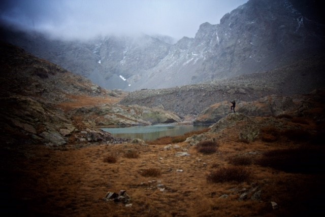
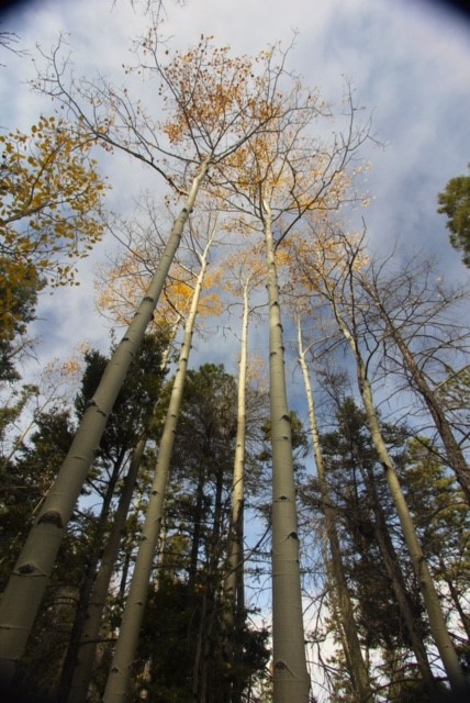
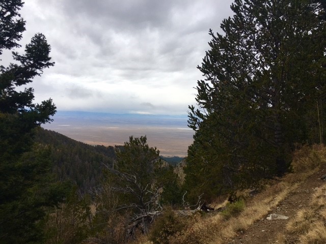
The following day we drove the punishingly rocky road to the Zapata Lake trailhead for what we thought would be an easy 4.6 mile hike to the lake. The trail itself was beautiful, wandering its way through evergreens and aspens, across streams and around scree slopes. The breath-taking views and crisp air were just what I imagined a mountain hike to be. Finally, with some relief, I reached the lake, accompanied by a light snowfall. About a mile short of the lake, my wife had made the decision to enjoy the view of the lake from a photograph. So I took some photos with my daughter and son-in-law who had semi-patiently waited for me and then we started back.
While the trail was beautiful, the hike was definitely more difficult than I or my wife expected it to be. The trail's claimed 4.6 mile distance made me question whether the surveyor had taken the same route we had. In addition, we underestimated the difficulty of adjusting to the higher elevations. The hikers we encountered from that area did not seem to have the same difficulty with shortness of breath and light headedness as we did. Only two days before, we had been living at an elevation of about 350 feet above sea level. Maybe next time we should give ourselves a few days to acclimate. Unfortunately, our itinerary demanded that we leave that evening. We definitely felt we did not have enough time to fully enjoy the area. We are looking forward to returning to the parks and spending more time exploring the San Luis Valley.
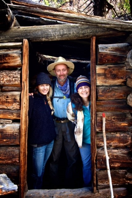
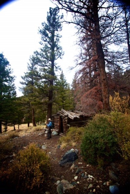
MY NOTES: I met the family earlier in the fall when I had decided to run the Zapata Lake Trail. They were sitting on a log bench next to a collapsing log cabin, attempting to rest and catch their breath in the altitude along a steep section of the trail. Being the tour guide I have become, with my increasing knowledge of the SLV, we looked at the valley floor about 2,000 feet below and though the Great Sand Dunes were not in view, we could see the San Luis Lakes so I explained the unique geology of why the lakes were there. We also discussed the San Juan Mountains, about 60 miles distant.
They told me they had climbed the dunes the evening before at sunset, had camped in the National Park, were from Cape Girardeau MO, and were now struggling with the altitude on this trail. Yep, I said, being from the Midwest originally and dealing with altitude adjustment on occasion, I recommend starting at about half speed and backing off your hiking pace from there if need be.
They had driven all night, which from experience, I knew was a distance close to 1100 miles. Tiring indeed. As Bob mentioned, distances are deceiving in the mountains because the Midwest never allows long distance views from much higher altitudes and somehow our mind's eye compresses distances, making mountain ranges and other things appear closer. The sand flat at the base of the sand dunes is the sand bottom of Medano Creek which spreads out over 300-400 yards across during spring snowmelt, similar to the width of the Mississippi River that flows past Cape Girardeau on its way to the Gulf of Mexico.
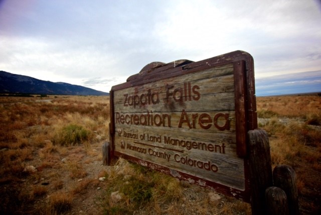
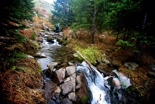
Bob accurately describes the rough road of 3.5 miles from Highway 150 to the Zapata Falls parking lot as it is truly a kidney bouncing washboard! The trail is a steep hike up a glacier carved valley cut by smaller streams coming off the steep mountains on both sides of the trail. And 'scree slopes' are boulder fields of millions of rocks the glaciers crushed and moved around to where the rocks now lie in piles. Hiking across scree fields is slow and methodical as the footing is treacherous in spots that can be ankle biters and breakers!
Weather moved into the upper valleys all along the Sangre de Cristo Range. I made it to the lake and was on my return trip in a light steady snow when along came Elizabeth. Chatted with her for a few minutes and found out she and her husband are presently in Puerto Rico doing horseback beach tours. Fun! I said. Found her husband Jeremy who had a nice camera and had paused for photo ops. I gave him my card and asked him to send some of his professional photos and I would have them posted at a later date on alamosa.org. I continued running and was also thinking that this trail was a lot further than 4.6 miles also. I have a pretty good internal GPS and my brain was thinking easily 5 and half plus miles one way.
Soon, I ran into Bob who asked me how much further. We chatted more about their trip itinerary. They were on a whirlwind tour of Colorado and Utah Parks. I said I know all the routes and cool places to see and gave him my card and told him to call me with questions.
He went up, I continued down. Ran into Julie his wife, and by now, at lower altitude, we had a mixture of sleet and cold rain. The rocks and tree roots were getting slick and she had made a wise decision by turning around. She knew her family would catch up. I walked with her for a half mile and we discussed mountain safety as she was not feeling great. Altitude sickness can be somewhere between annoying and dangerous. Most people experience the annoying - headaches, fatigue, shortness of breath, and thirst. But they are less familiar with disorientation caused by lack of oxygen to brain cells, hypothermia, and pulmonary edema. I walked her through one slick steep section and said farewell.
I was a cold wet dog when I returned to my car. Was happy to get down the road and back to Alamosa to dry and warm. Later in the afternoon, Bob did call me and asked me to join them for dinner in town and bring my western maps. Enjoyed their company and their excitement for further adventures to more National Parks and Monuments Gave them a few travel tips and told them to keep in touch if they had questions. I did receive several questions from them over the next few days via text and could tell they were enjoying, but also overwhelmed by the size of the western states!
Enjoy Bob's account of their adventure, Jeremy's pics, and take mental notes about time, distance and fatigue factors if you are coming from low altitude. Having spoken to Kristi Mountain Sports here in Alamosa, I found out the trail is close to 6.5 miles one way! Ignore that sign at Zapata Falls that says it is only 4.6 to the lake. Bob was correct - the surveyor he mentions, had a defective distance measuring device!
Look for a more comprehensive trail guide of the San Luis Valley coming in the spring of 2017 on alamosa.org. Accurate distances and trail descriptions, including the pleasures and perils that may be encountered, will be part of the guide. See ya next spring, summer and fall.