Mid-March means calendar winter is nearly over. The weather is warm and sunny somewhere. This is a time to renew our spirits and contemplate whatever the first fifth of 2016 has given us. And for all of us, college students or not, we all need a break! Traveler's scatter according to their interests and priorities. Many flock to ocean beaches, others flock to find good spring snow conditions, while others, like me, have a well-defined traveling goal of 'spontaneous wandering.'
After a Saturday at the Monte Vista National Wildlife Refuge for the Crane Festival, it was now Sunday, and I decided to wander out to the Great Sand Dunes National Park. However, I decided while driving out to the Dunes that I would attempt to run the Mosca Pass trail instead of always going up the Dunes. What I really wanted to do was go up Medano Pass, a bit further to the North, as this was the pass that Zebulon Pike, for whom Pikes Peak is named, and the guy President Thomas Jefferson sent out west in 1806 -1807, to map the southwestern portion of the Louisiana Purchase which America had acquired from France in 1803. The new American West was the happening place to be! But Medano Pass is a long way on foot and probably had too much snow up higher without proper equipment like snowshoes. But these two passes, and the low mountain ridges between them, are the reason why the Sand Dunes are there. These passes provide a funnel of sorts for westerly winds to exit the San Luis Valley and drop their loads of sand exactly where the future National Park Service had hoped they would! In all seriousness, I do like how Zebulon Pike wrote in his travel journals, that upon seeing the dunes for the first time, they looked like ocean waves upon a turbulent ocean, only of a different color. (Good description, though he could have added, 'frozen in time.')
Mosca Pass was once a toll road that lead traveler's from the Eastern Plains of Colorado into the San Luis Valley. The toll road has quite a lot of history beginning in 1870. Small handbooks are available at the trailhead sign-in spot to carry with you on your hike up the Pass. Great idea. Quite informative, but I only did a speed read and left one of the two copies there.
At the visitor’s center, I ran into a car load of college students piling out of an SUV, so I said enthusiastically, "Let Spring Break begin!" One of the girls, being the spokesperson for the group, loudly proclaimed back to me, "Yeahhhh!!" Smiles from the others confirmed her declaration. I went into the Visitors Center and inquired about the snowpack situation. The park person gave me the number of the resident hydrologist, and when I mentioned I was going up the Mosca Pass Trail, he asked me to stop in with a trail update. I assured him I would do so.
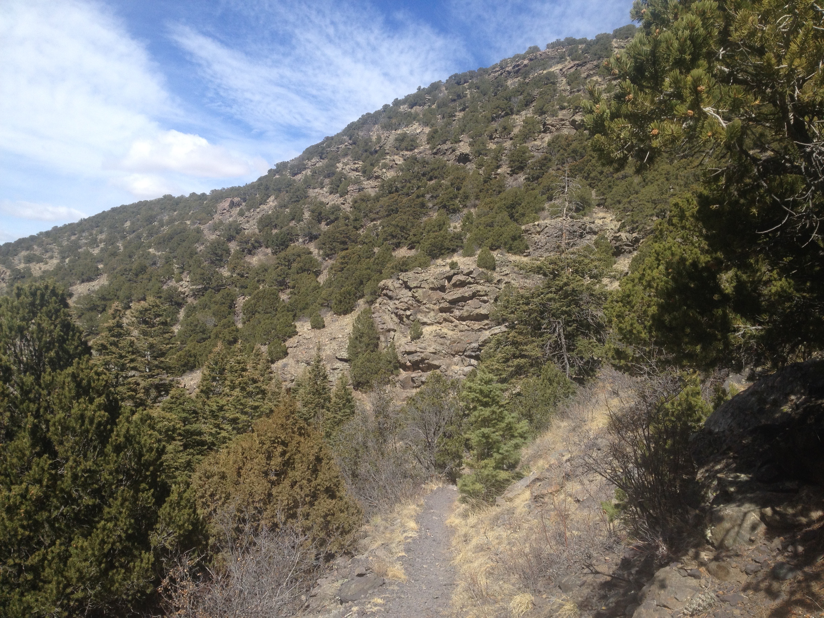
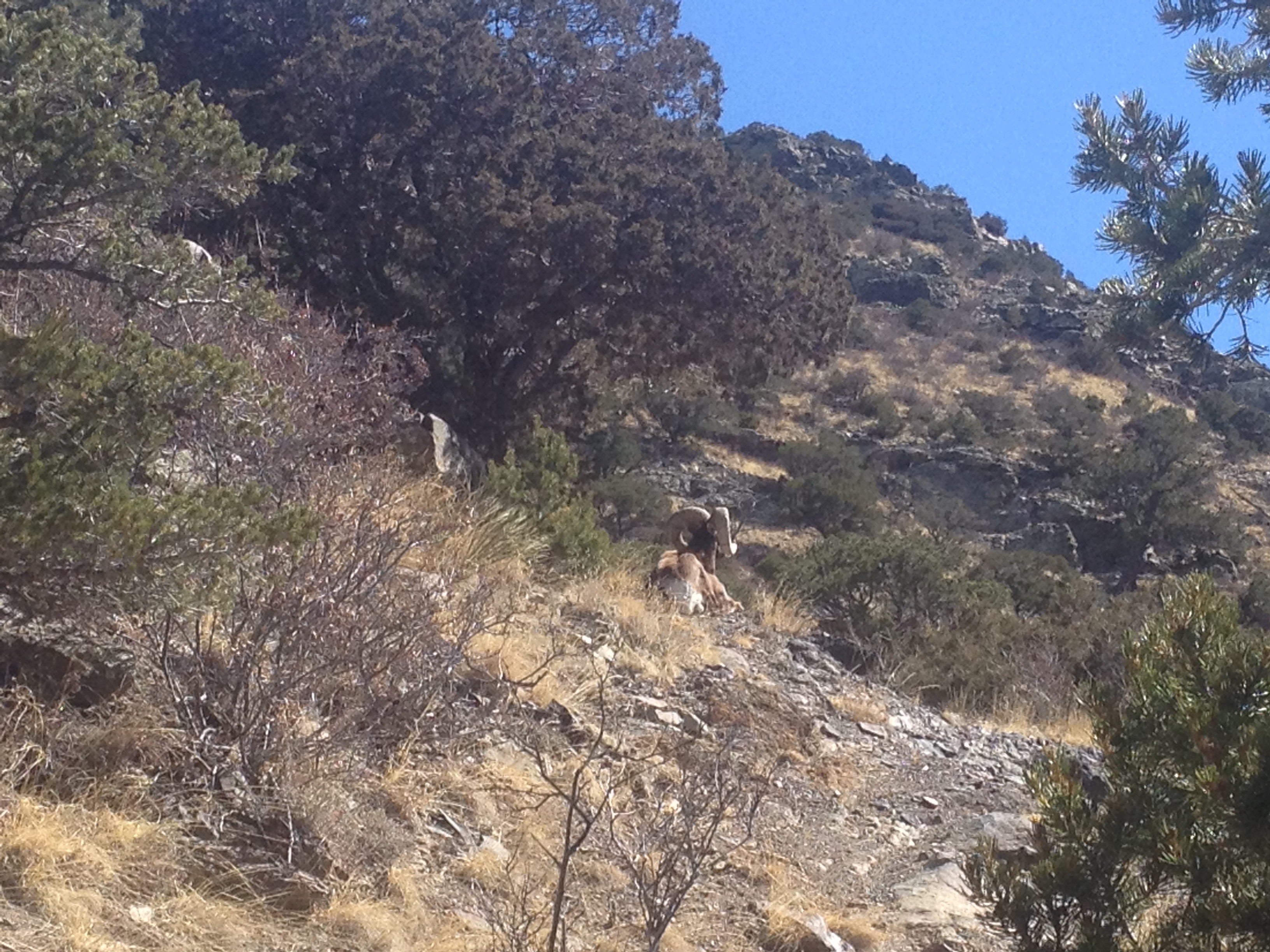
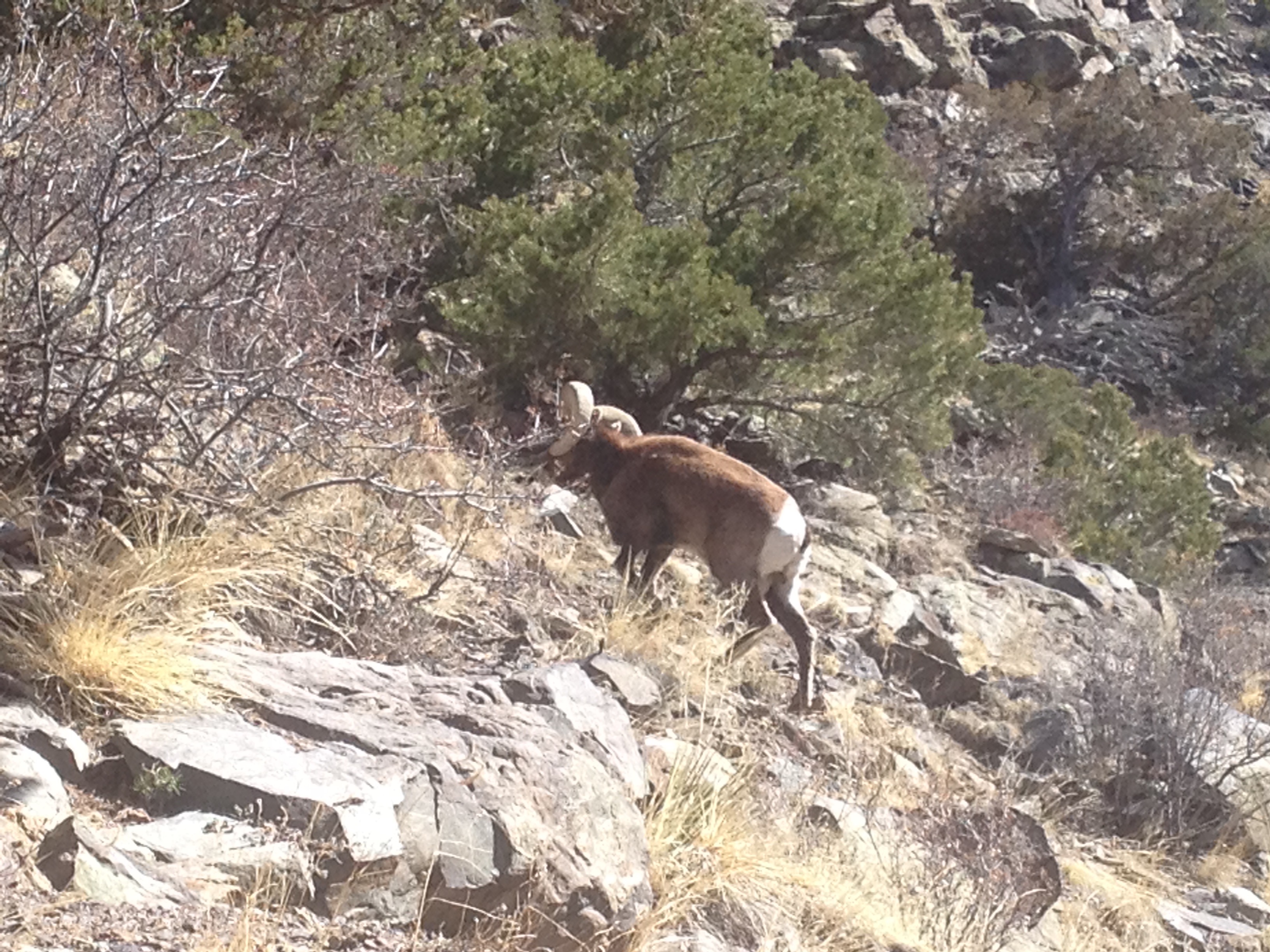
The trailhead for Mosca Pass begins near the Visitors Center so I left my car there, and took the trail through a forest fire burn zone, with burn-scarred tree skeletons waiting to once again be part of the soil, many years from now. I signed in at the trailhead. Last people to sign in was a week prior on Sunday, the 6th of March. Their message in the comments section was - "Amazing, so awe inspiring!" The trail begins in the Mosca Creek ravine and in mid-March, the creek is still mostly hidden from the sunlight. As a result of cold nighttime temperatures, the snow that had fallen over winter on the trail and was in the shade, was hanging on, in the form of a trampled icy, crusty and slippery surface. Caution is required, as the trail has a steep drop-off into the creek, so it would not be wise to slip and slide down there. I began the huff and puff on the steep beginning. The Trail is 3.7 miles to the top of the pass one way so I settled into a slow pace. The intermittent patches of ice and snow lasted for a half mile before the trail past that point is on the south facing side of the mountain and the sun bakes the trail dry. A strong wind was at my back, the sun was intense, and I was warm and comfortable as I trekked upward. I stopped, turned around and I could now see glimpses of the dunes through the gap in the mountain. As Pike had said, the dunes looked like large ocean waves of a tan color. I proceeded, but not far. On the trail, 30 yards ahead of me, sat a Bighorn Sheep ram. He was faced uphill away from me. I had a piñon pine to my right on the creek ravine side. The drop into the creek was a steep rocky 60 footer. "Mr. Ram!" I said, trying to get his attention, show my respect for him, while positioning myself near the tree to protect from a possible confrontation. I called out several times to him with no response and finally clinked rocks together. To that he did respond, and slowly was able get up. At that point, I knew he was sick, old, or both. He barely acknowledge me. He struggled to walk, he paused, tried to graze on a bit of dry grass on the side of the trail. Had the winter been severe, I believe he would have died already. I stepped
onto the trail but did not approach. He tried to climb up the hillside. In his youth, he could have bounded away and within seconds I would have lost sight of him, or, he may have challenged my presence. Even in his physical condition, I decided my trail day was over, as even in his sickly condition, I was no match for his strength if he did have one last charge in him. Mother Nature gives her creatures amazing protection tools. I chose to honor and respect this old boy and let him have his space to die with dignity and be food for scavengers, or be taken by a mountain lion, or perhaps a pack of coyotes. Such is nature. Like days when thunderstorms threaten lightning - by turning around, I live to run another day. I bid 'Mr. Ram' farewell and about-faced on the trail. I told a few people at the trailhead about the ram when I returned to the parking lot, but they were not going up that far.
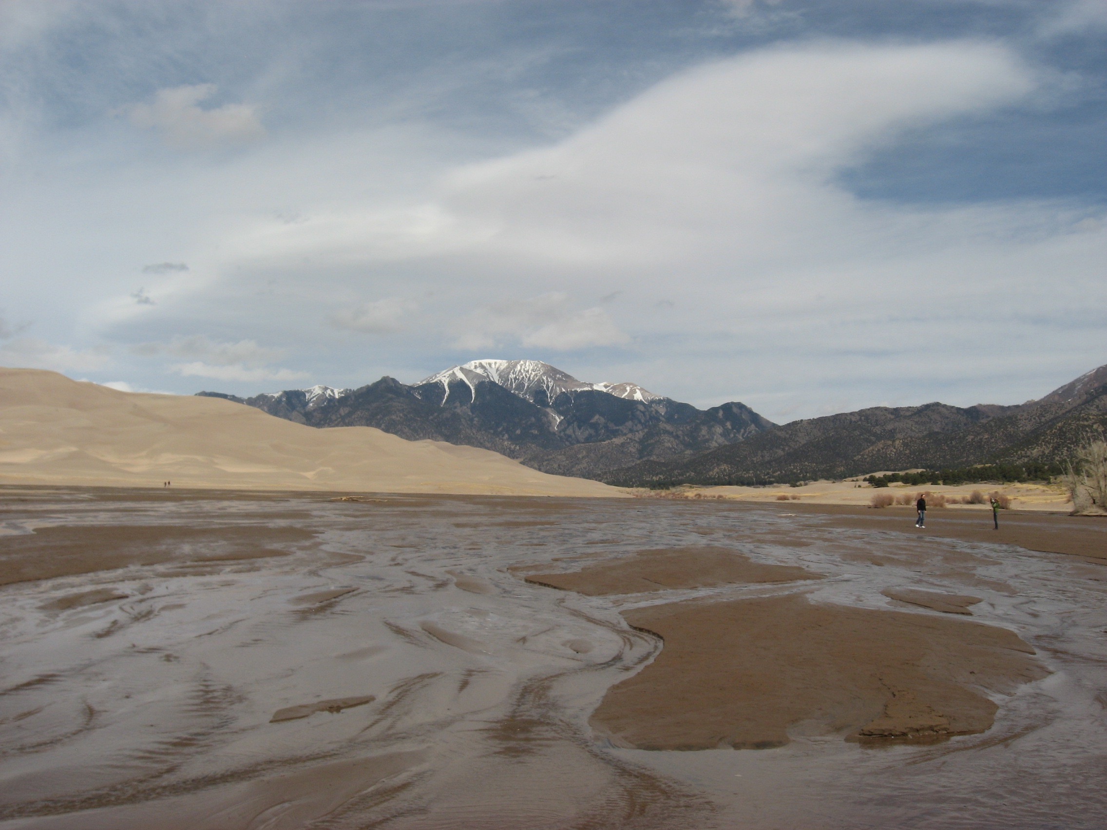
Next, I drove to the Main Dune Parking lot. Amazingly full but why not? Temps were around 50, and there was a bit of a stiff cool breeze but the warm March sunshine made the surface of the sand pleasantly warm. I heard several languages being spoken, observed a number of families who were playing on the beach near Medano Creek, which was flowing steadily, though not nearly like it would be in 2 months in Mid-May through June. Several small children had there plastic shovels and buckets out for use. Instead of my usual stagger slip and slide running up the dunes, which I love, I wandered the beach as if I was strolling along the lapping waves of an ocean. I watched the water move steadily in Medano Creek and observed the artistic sand forms created by the water waves flowing downstream. I examined logs of driftwood that have been carried from another burn zone high up on one of the mountain ridges between the two passes. I picked up and inspected rocks, as there had been a mining company here that had found some quartz with gold specks in it but never enough to be profitable. Yes, prospecting for gold, that's what I was doing! Found a few pieces of white quartz that did have some iron pyrite flecks infused into the rock, also known as fool's gold. Tossed them back into the sand for someone else to study. Time to hit the road but not before I stopped back into the visitor’s center to make my trail report. I ran into a few people I had seen the day before at the Crane Festival. Greeted them and asked how they enjoyed their weekend. "We had a blast!" Sums it up. Crane fest to take pictures and gain knowledge about bird species and their migrations, a day at the Great Sand Dunes for spontaneous wanderings, being in the mountains, and being a part of real nature as it happens. I think everyone I met could claim they were having a successful 'break.'
Further reading - Zebulon Pike's expedition of 1806-1807. Mosca Pass toll road. The Great Sand Dunes. Plenty of good information and pictures on websites. Oh, and Rocky Mountain Bighorn Sheep.
Weather Note: I left the San Luis Valley on Monday afternoon. High winds from a spring snowstorm up north were ripping east across the sunny valley, with only a few high clouds. All the snowcapped Sangre de Cristo Mountains were visible from Poncha Pass to the north to the New Mexico border on the south except for where the Great Sand Dunes are located. A large tan cloud veiled them completely. The Dunes were having a grooming day, to remove tracks, reshape themselves, and get ready for the next set of visitors!