
Length: Variable-25 Miles of Trail in Total
Difficulty: Variable Based on Trail
Driving Instructions
From Alamosa, drive 15 miles west on Highways 160 and 285. In Monte Vista, take a right on 285 and drive 18 miles north towards Center. See the sign for Penitente Canyon and take a left, (West) and drive 6 miles to town of La Garita. Continue West on G road which will turn to gravel. Within a 1/2 mile the road forks. Take the left fork on County Road 38A - 1/2 mile to sign for Penitente Canyon. Take right and follow road northwest to entrance. Pass numerous campsites and road dead ends at trailhead.
Trailhead Parking
On busy weekends when there is good weather, the canyon may be busy as it services rock climbers, hikers, and mountain bikers. If the main parking lot is full, it may require turning around and finding a spot in the overflow parking areas. It is free for day use, but there are fees for camping. Pets are allowed on a leash.
Length
Penitente Canyon trails offer many interconnecting loops in a maze that can be from 1 to 5 hours.
Elevations
7,856 to 8,289 feet
Description
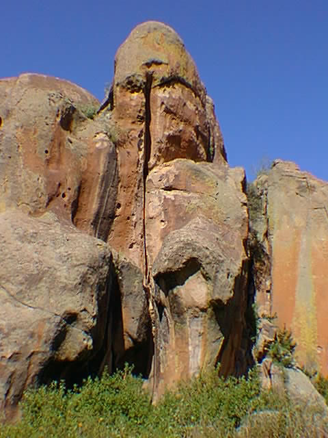
The canyon is a labyrinth of trails that weave their way in and out of rock formations. Most of the climbing routes, of which there are over 300 (one pitch climbs of 50 - 100 feet), are within a mile. The trails will wind their way up to the top of the rocky plateau and offer 360 degree views. Plan to encounter hikers, mountain bikers, runners, and climbers hauling gear to climbing routes. The difficulty level varies on these trails from easy to difficult- there is something for every level. Hiking parts of the trail can be difficult on some of the highly technical mountain terrain.
Terrain
The rock formations that make up the canyon have lots of vegetation along the trail from bushes, and many species of pine and aspen trees. It is also filled with desert plants of cactus, yucca, and other species. Be aware of your surroundings, as there are a few treacherous spots.
Water/Bathrooms
There is a water station near the entrance to the Canyon. Bathrooms are located in the campground and trailhead area. It is best to pack in your own water just in case.
Pleasures and Perils
This hike offers unique geology and terrain. It has great views that are wildly different than the Sand Dunes directly across the valley - 60 air miles! This is a high desert environment filled with things that can stick, stab, sting, and bite. Rattlesnakes are common but with common sense, can be avoided. Best to keep pets and kids close by.
Significance
Geologically, La Garita Caldera was one of the largest volcanic areas in the country though not as well known as Yellowstone. Historically, the Spanish came through here gathering wood with wooden ox carts in the 1820s and 30s. Their trail ruts are easily seen on parts of the upper trails.
Notes
The store in La Garita has variable seasonal hours, so its best to bring provisions with you. Group camping is available and many small groups bring all their ‘toys’ for several days - climbing gear, mountain bikes and hiking shoes - for an active vacation.


