The title rhymes if Penitente is pronounced in Spanish with the 'e's being long 'a's as in English. Fun with words and languages. Unlike the mountains surrounding the San Luis Valley, as well as the Great Sand Dunes, Penitente Canyon hides from view until you are actually in it. One of its charms!
On the first Saturday of May, a dry heave hurricane was blowing in from the Southwest as I drove north on Highway 285 heading north from Monte Vista. Several tumbleweeds 'attacked' my car at high speeds as they were doing what they do best in high winds, tumble! One hit my car door and exploded and the other got lodged in my grill. All part of the fun when driving in the spring! This is how tumbleweeds spread their seeds.
The turnoff for La Garita and Penitente Canyon is 18 miles North of Monte Vista or the same distance south from Saguache. Turn west on County Road G. I get a Pavlov's response when I see brown signs that indicate a Recreation Area or National Forest access road. Like a dog whose mouth waters at the prospect of food, I get excited butterflies in my stomach for a nice trail. I've accepted the nature of my beast! Find trail, will run it!
I passed through La Garita at the 6 mile mark, consisting of a few houses and the landmark Trading Post. I continued west and could see the Spanish Chapel on the hill to the north. The paved road splits and the gravel road to reach the canyon goes left. I followed signs to the main parking and camping area. There is an overflow parking lot in about a mile which had cars in it so I pulled in thinking the main lot was full. I parked and stretched for a bit. I could hear the wind above me chasing dust across the sky, but in the canyon, the winds were light. I walked up the gravel road and met several hikers with their dogs. The golden retriever in the group came running toward me and began viciously licking me above my left knee. I retaliated by scratching her ears until she rolled onto her back in the gravel. I gave her the special 'running shoe belly rub.' The dog was not hating life. The owner apologized of course, as many owners do, but I mentioned it is hard to change the nature of the golden retrievers! If I've met 10,000 goldens, I think I have met one who was mean.
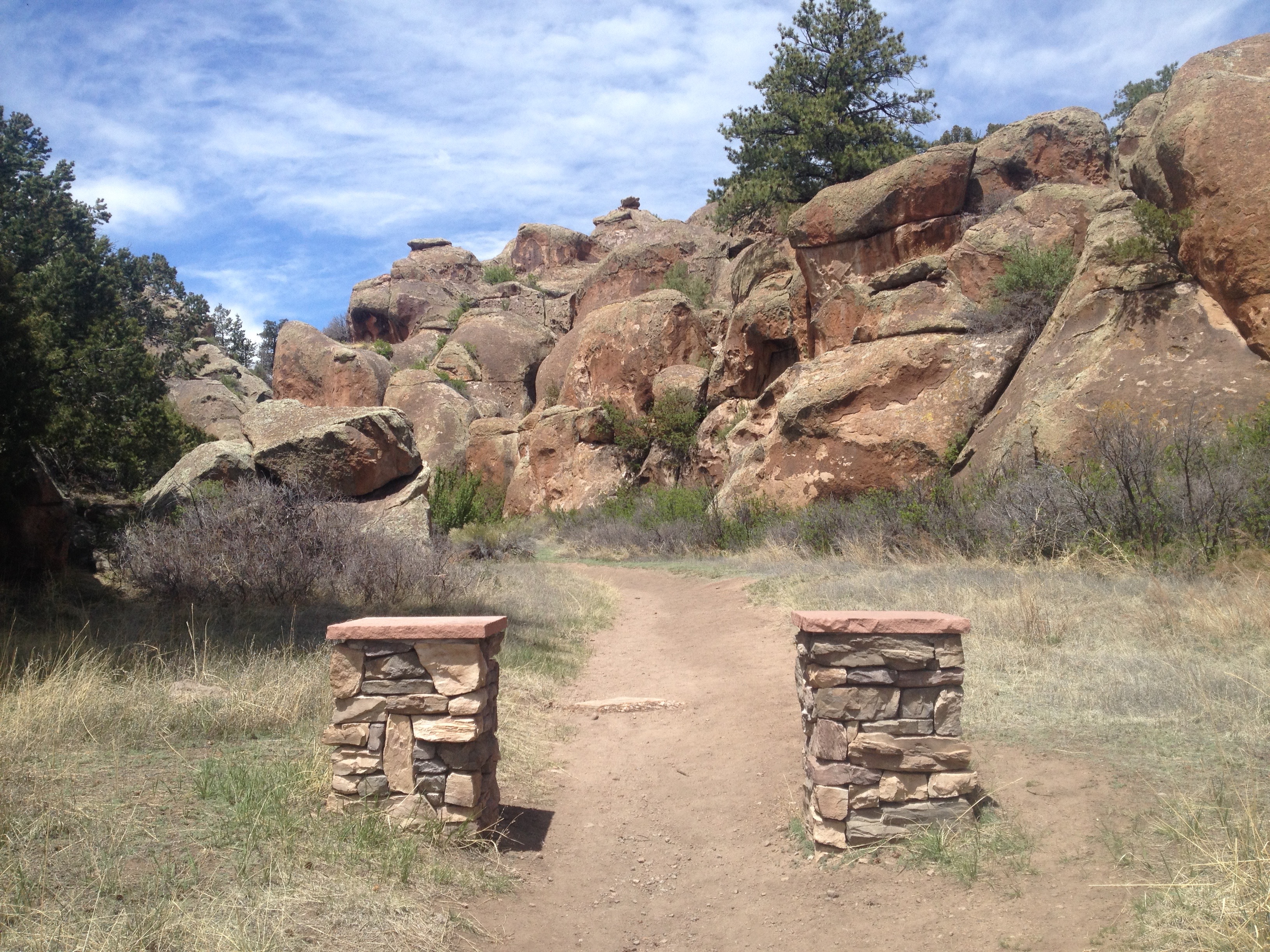
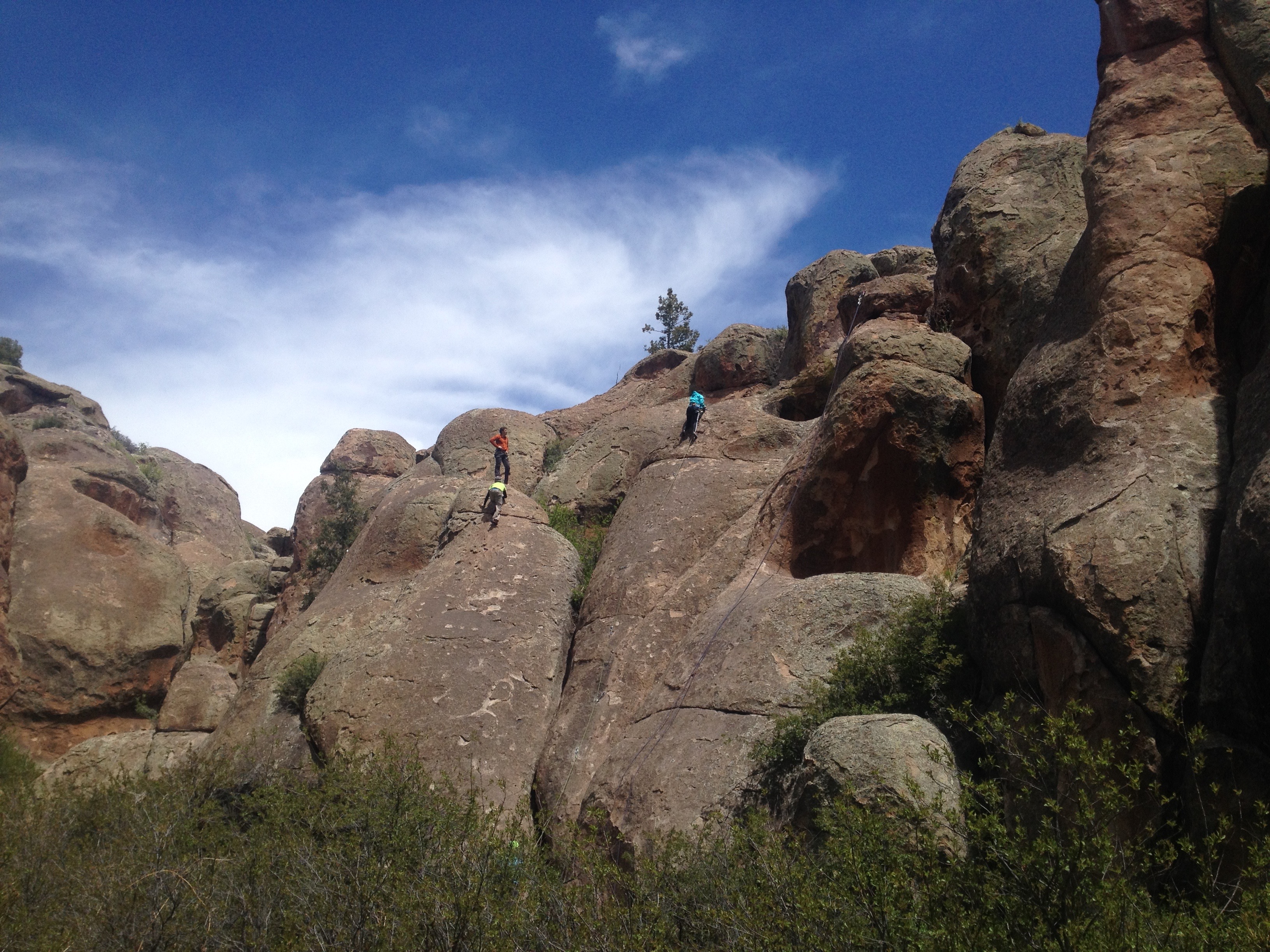
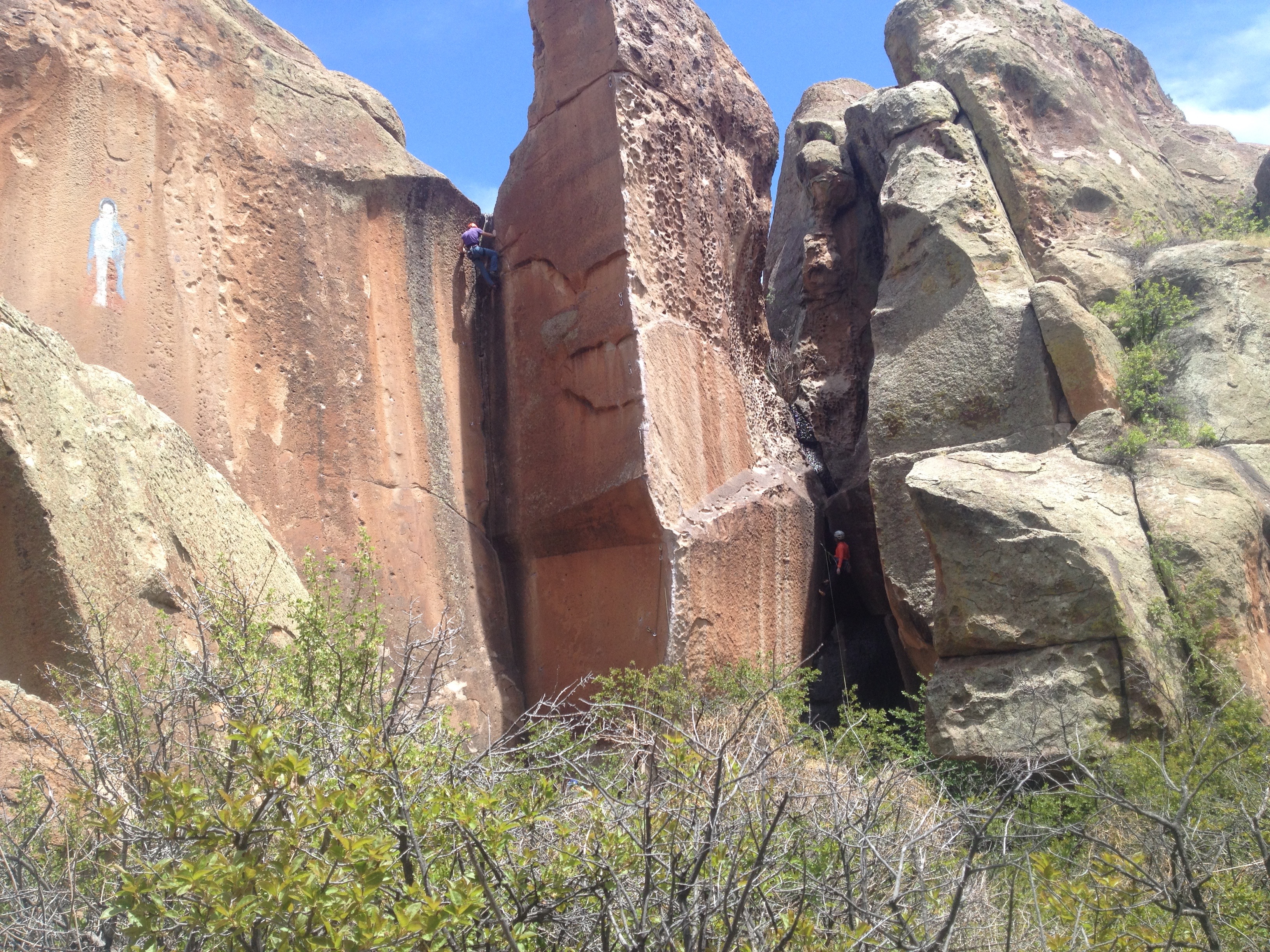
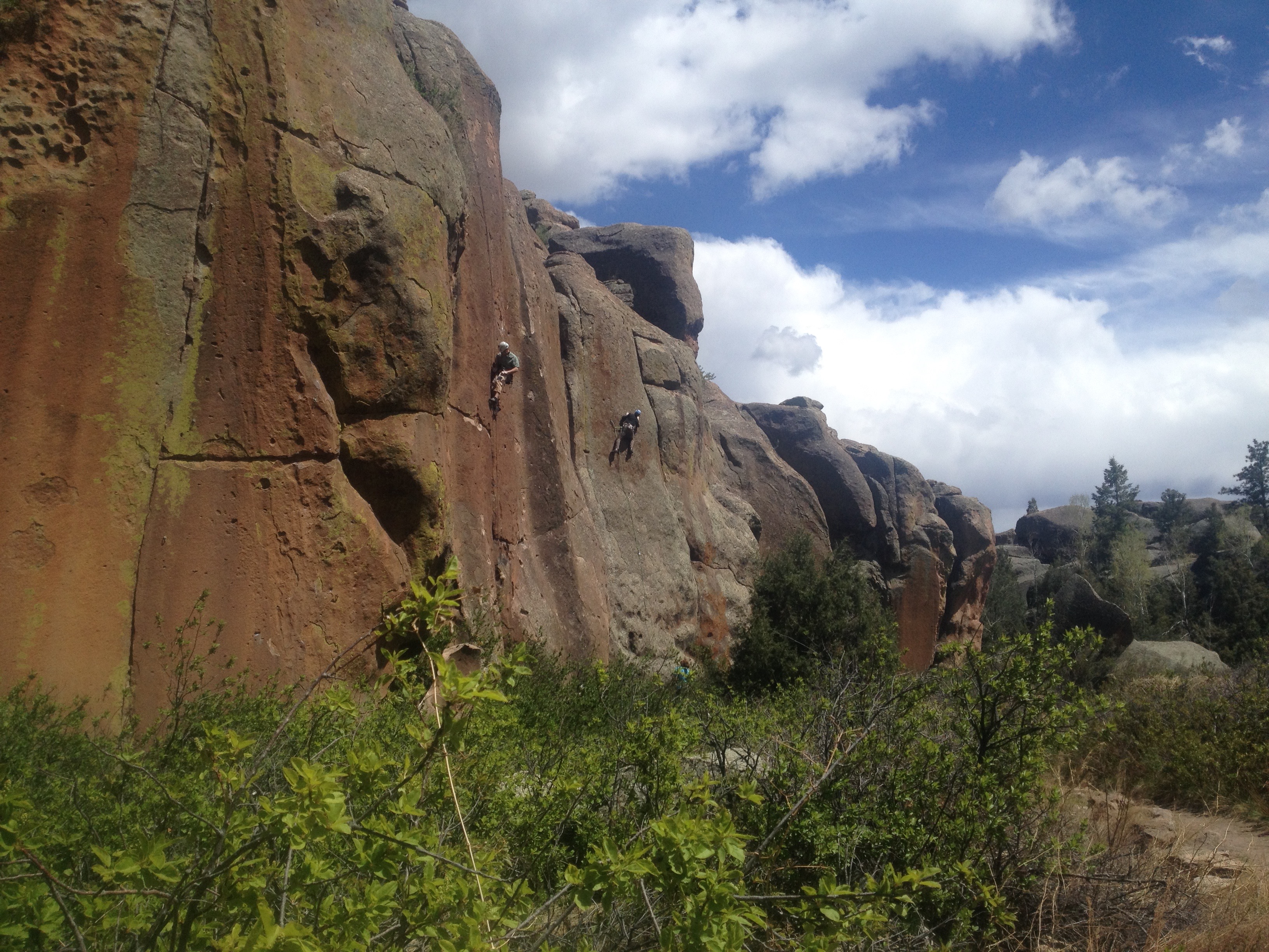
I continued through the main parking lot which was full of vehicles so I knew rock climbers were here in force. I studied the trail signs at the entrance before taking the trail into the main part of Penitente Canyon which is rock climbing's one pitch paradise. A pitch in climbing is defined as the height of climbing on a rock face which won't go higher than beyond the length of rope that allows the person climbing to be protected by their belayer - a belayer is a person who is maintaining tension on the end of the rope not attached to the climber and uses their body, or a tool, to quickly 'lock' the climbing rope, so if a climber slips, the climber will not slide far down the rock face. The belayer lets the climber get secure hand and footholds before loosening the tension on the rope for the climber to continue, or, if the climber is fatigued, the belayer can lower the climber down slowly and safely. The 300 pitches, or climbing routes, in Penitente are between 50 - 80 feet. I did not go far into the canyon when I found the first few routes up the cliffs to the right, occupied. One climber may have been about 10 years old. He was all full of excitement as I guessed it was his father who was belaying him. Young kids are often quite agile on rock faces. Climbing is a good teacher for safety and discipline, not to mention the enthusiastic fun kids generally have. Hopefully they gain a healthy fear factor too!
I watched as I ran, as the trail is smooth enough that I did not have to pay attention to every footfall. A runner passed me as she headed toward the Parking lot. We exchanged no words, only smiles in acknowledgment that we were both enjoying our day in a different way than the climbers.
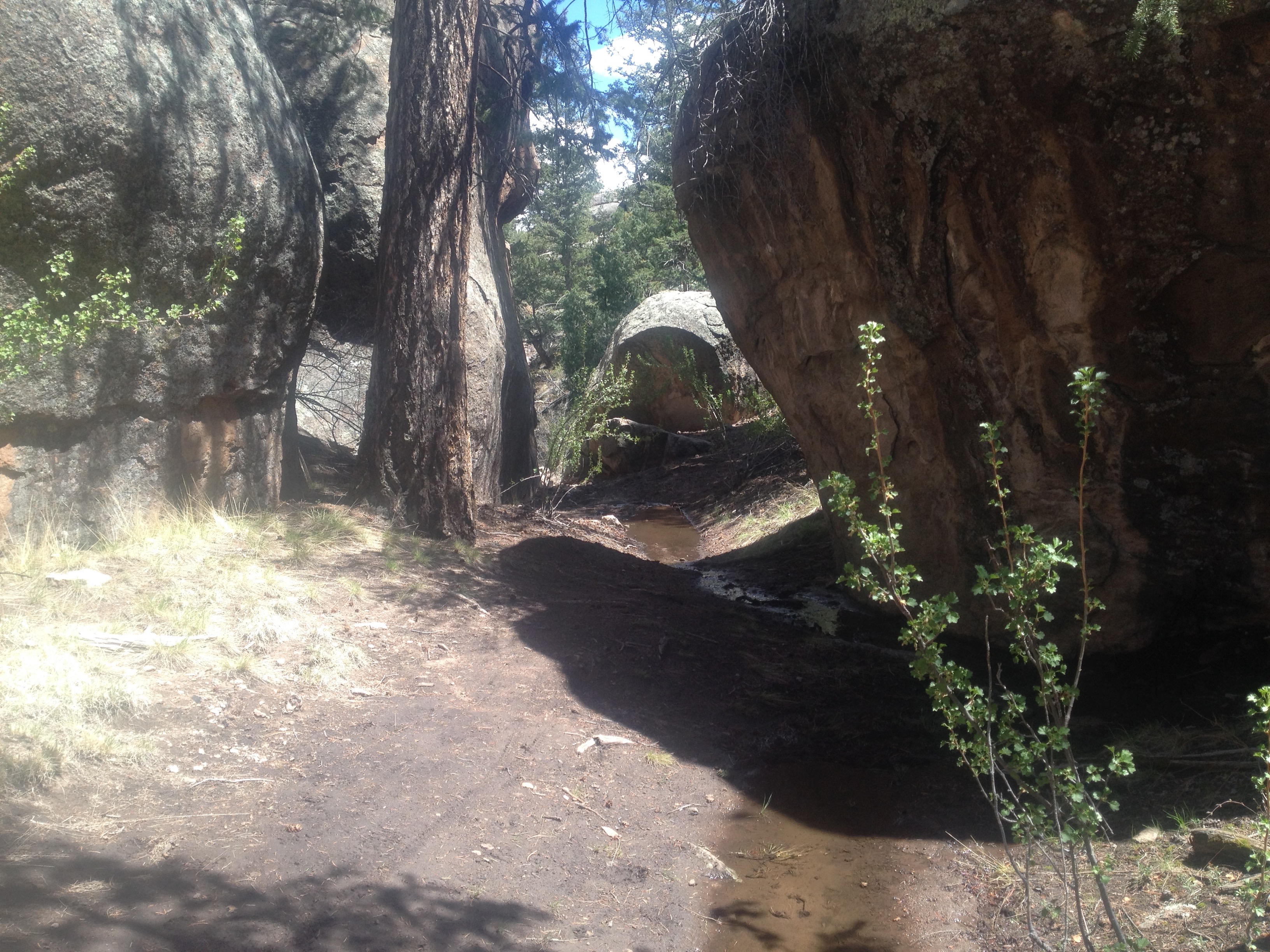
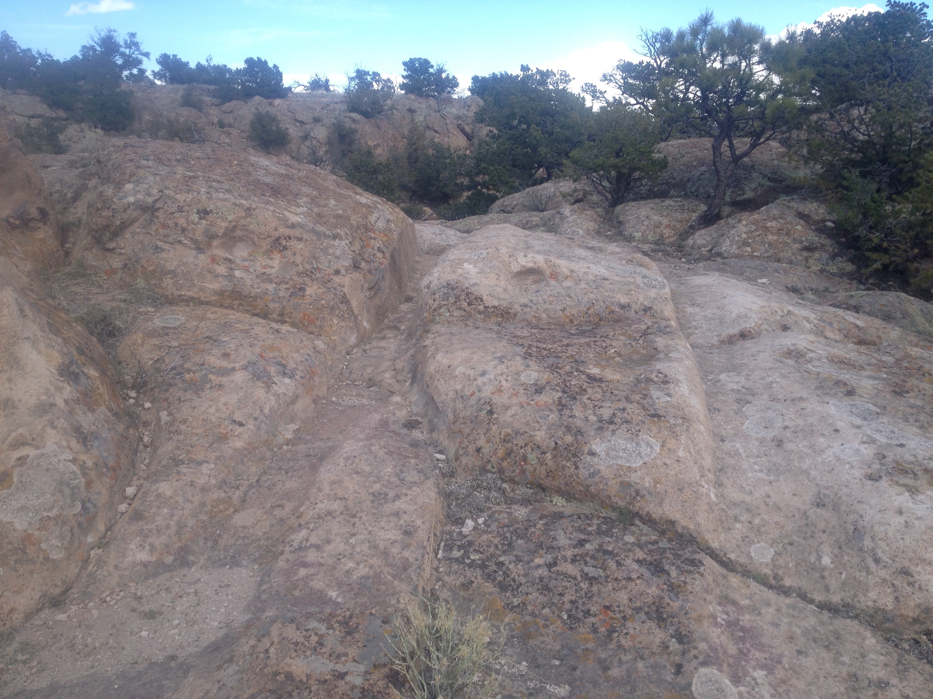
I passed most of the climbing routes and headed into the tight part of the canyon. A snowmelt stream now slowly flowed along the trail. Soon I came to a section with deep mud near a rock wall. The underbrush opposite, was quite thick. My technique became to straddle the mud with one foot on the underbrush dry side while the other foot found foot holds on the rock. I alternated feet forward and successfully traversed the 30 feet or so of nasty black mud. The next part of the trail is like a tunnel in places, through the rocky canyon walls and the ponderosa pines that grow in the dark shadows of the canyon bottom. This part of the canyon ends and the trail goes up through gaps in the rock and comes out on top of the volcanic tuft. I stop at a Trail Confidence sign which is mostly for mountain bikers to find their loop trails up on the rim areas of the canyon. Long distance views emerge, as I can look east across the valley to the snowcapped Sangre de Cristos. The wind speed picks up on the canyon rim as I knew it would! I am now ready for consistent running, following the trail over rock, on dirt, and through stream beds where I followed mountain bike tracks from recent rains. Part of the runner's 'high' of trail running is the focus required to follow the trail as it goes up, down and around the sparse piñon pine/ juniper forest, interspersed with rock formations and a variety of bushes, yuccas, and cactus. The uneven terrain makes it a course of concentration and coordination between, feet, legs, eyes and brain. I cross an open area of rock where the wind picks up even stronger and a mountain biker pops over the ridge in front of me. I step off the trail and he informs me there is one more rider coming. I thank him. Common professional courtesy on shared trails. I am running on the volcanic tuft, which resemble sandstone, and I see interesting ruts in the surface. I pay them no mind until I reach a sign, but I had to be on the other side of the sign to read it. Wow, those ruts are 160 plus years old, made by carts, (carretas) pulled by oxen to gather wood as there are no trees on the lower valley floors. Love informative educational signs!
I find a road and follow it to Witches Canyon. I take one route south along an arroyo containing flowing water from recent rains. I'm thinking this is not a good way to continue so I backtrack and go up Witches Canyon to the Northwest but this too, seems to not being going where I want to go. I bushwhack up a hill to the east and come to a familiar trail sooner than I thought. I got lucky. I run over the oxen cart path again and find the trail sign to drop back into the climbing area of Penitente. I find a young couple doing a route on a short rock face far from the main climbing. They wanted solitude they said. I told them I would leave them to it and continued on the trail. Their dog kept a close protective eye on them while they climbed and one on me. I successfully retrace my steps across the black mud flats and continue down the canyon. I come upon a climber who is reeling in his rope from one climb, preparing for his next route, and we talk. He was here with a group of climbers from Pagosa Springs who recently discovered Penitente. They are regulars here now, he said, as they really like the number of challenging short routes.
I carry on and spot the runner I had seen earlier. She is sunning on a rock outcrop near the trail. She hears my footsteps on the gravel. She looks up and again she smiles. I smile back at her and nod, saying in 'runners language,' yep, that was a good run! Not a long one, not to strenuous, just a nice Saturday in May in Penitente.
Best maps I found online:
Climbers - - Penitente canyon websites - scroll till you find Elevation Outdoors - five reasons to climb in Penitente Canyon
Mountain Bikers, hikers, runners - trailforks.com Penitente Canyon
PLEASURES: Scenery, beautiful canyon, can easily find solitude if desired. Campers can bring all their toys, running/hiking shoes, climbing gear, mountain bikes, dogs, grills, ice chests with all the fixin's, etc.
PERILS: This is high desert. Along with deserts come living things that can stick, stab, bite or sting. Weather, as in storms, can move in with cold rain (hypothermia) and lightning (zapped into nonexistence). Keep an eye on the sky. Be prepared to bail out. The terrain is rough. Plenty of roots, rocks and steep drop-offs to hurt climbers, runners, hikers, and bikers. Plenty of places where a person could be killed or even injured (a joke amongst rock climbers I knew in college). I am amazed at what some mountain bikers can negotiate. Plenty of flat tires though! HONORABLE MENTION - though on the upper end of their range, rattlesnakes can easily hide in the thick brush along the trails and the edge of the climbing areas. Keep an eye, and ear out for them!